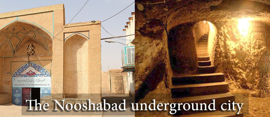
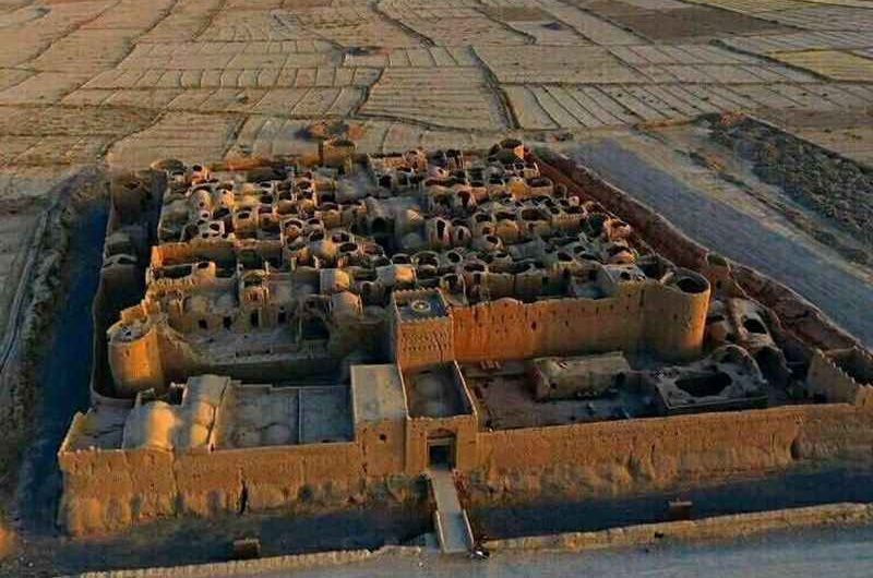
Introducing the Nooshabad underground city Nooshabad underground city, a journey into the depths of Iran's history! In this article, we'll describe one of the most amazing cities in the world, the underground city of Nooshabad. We’ll share interesting and exciting information with you about this ancient place, which is a relic of the Sassanid era and holds a history of 1500 years, and the story of the discovery. The underground city of Oui or the Nooshabad underground city is an underground and ancient city under the urban texture of the new city of Nooshabad. Nooshabad is one of the cities of Aran and Bidgol county in Isfahan province. This city, which is known as one of the capitals of the Sassanids in the Anushirvan period, is located 5 km north of Kashan city (the city of ancient Sialk hill) and 3 km northwest of Aran and Bidgol city. Although the history of the creation and use of these buildings goes back to the Sassanid era and the beginning of Islam, but based on the evidence, it was utilized in later periods, until the Safavid period. The structure of the underground city of Nooshabad The Nooshabad underground city contains a dense, complex, and extensive structure that consists of nested narrow corridors and small-sized rooms. The Oui complex was constructed under the old structure of Noushabad city and has expanded to the current level of the city. The area of the discovered part of the Nooshabad underground city is about 12000 square meters, which has been expanded on both horizontal and vertical levels due to the connection between the neighborhoods and the protection of people's lives and property in times of insecurity. So far, 3 important parts of Noushabad underground city have been discovered and explored; The first complex is about 1000
Introducing the Nooshabad underground city
Nooshabad underground city, a journey into the depths of Iran’s history!
In this article, we’ll describe one of the most amazing cities in the world, the underground city of Nooshabad. We’ll share interesting and exciting information with you about this ancient place, which is a relic of the Sassanid era and holds a history of 1500 years, and the story of the discovery. The underground city of Oui or the Nooshabad underground city is an underground and ancient city under the urban texture of the new city of Nooshabad. Nooshabad is one of the cities of Aran and Bidgol county in Isfahan province. This city, which is known as one of the capitals of the Sassanids in the Anushirvan period, is located 5 km north of Kashan city (the city of ancient Sialk hill) and 3 km northwest of Aran and Bidgol city. Although the history of the creation and use of these buildings goes back to the Sassanid era and the beginning of Islam, but based on the evidence, it was utilized in later periods, until the Safavid period.
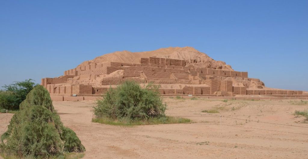
Zigurat of Choga Zanbil The ziggurat is an ancient temple of the Elamites, based on a four-story square plan with a temple top and an estimated height of more than 50 m, surrounded by numerous buildings, temples and palaces, and protected by three walls. The ziggurat consists of a huge mud brick structure, reinforced by wooden beams with an external coating in fired brick, which also allowed its connection with the outside. Each floor of the ziggurat was used for specific functions: at the top of the building was the temple proper, the "sanctum sanctorum", with an altar and statues dedicated to the patron deity, to which only the priest-king had access. On the middle floors there used to be schools and along the stairs were the priests' rooms. In the lower part, there were warehouses to store the goods that would be used in case of need, and archives to keep the clay tablets on which the contracts or the quantities of goods delivered to the temple were recorded. This sacred place gathered cults and deities from all the provinces of the kingdom. Several palaces were built to the east, next to a monumental entrance gate, also called the royal gate, with a large courtyard. The ashes of the royal family were also found in a palace intended for royal funerary worship. In 1979, Chogha Zanbil became the first Iranian site inscribed on the UNESCO World Heritage. If you are passionate about mountains, anthropology, historical landscapes and the fascinating culture of the Middle East, SITO Travel will help you organize your trip to Iran. Contact us because our experience is born and developed in this field.
Zigurat of Choga Zanbil
The ziggurat is an ancient temple of the Elamites, based on a four-story square plan with a temple top and an estimated height of more than 50 m, surrounded by numerous buildings, temples and palaces, and protected by three walls. The ziggurat consists of a huge mud brick structure, reinforced by wooden beams with an external coating in fired brick, which also allowed its connection with the outside. Each floor of the ziggurat was used for specific functions: at the top of the building was the temple proper, the “sanctum sanctorum”, with an altar and statues dedicated to the patron deity, to which only the priest-king had access. On the middle floors there used to be schools and along the stairs were the priests’ rooms. In the lower part, there were warehouses to store the goods that would be used in case of need, and archives to keep the clay tablets on which the contracts or the quantities of goods delivered to the temple were recorded.
This sacred place gathered cults and deities from all the provinces of the kingdom. Several palaces were built to the east, next to a monumental entrance gate, also called the royal gate, with a large courtyard. The ashes of the royal family were also found in a palace intended for royal funerary worship. In 1979, Chogha Zanbil became the first Iranian site inscribed on the UNESCO World Heritage.
If you are passionate about mountains, anthropology, historical landscapes and the fascinating culture of the Middle East, SITO Travel will help you organize your trip to Iran. Contact us because our experience is born and developed in this field.
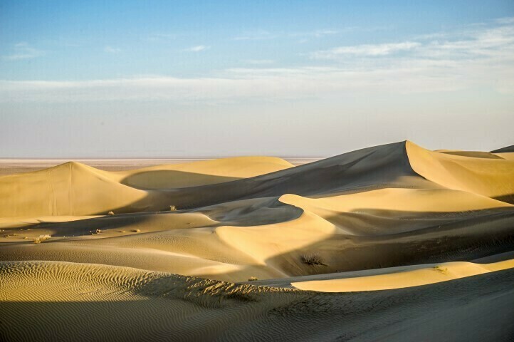
Varzaneh The hidden gem in the geographic center of Iran. It is a small city located on the edge of the Dasht-e Kavir desert, and it contains architectural elements and the typical landscape of the desert region of Iran. Varzaneh is a curious destination for those who like to explore popular places and rural culture. In this city ancient traditions are preserved that have disappeared in the modern part of the country. It is a good starting point to explore different tourist attractions, such as the ruins of an old caravanserai, volcanic mountains, sand dunes, and a salt lake. Old Bridge In Varzaneh, the houses have a particular style, built in brick, with wavy roofs, long narrow chimneys and wooden doors. Near the Zayande Rud River, the main attraction is the ancient bridge, built during the Seljuk dynasty. Its arches reflected in the water create a cinematic scene. Jama Mosque The main visit of Varzaneh is undoubtedly the Jama mosque, built in brick 600 years ago. The mosque has a cylindrical minaret and a dome, which can be seen from any corner of the city. The mosque has a main entrance covered with tiles, with geometric motifs and calligraphic inscriptions. In Varzaneh, women traditionally wear a white chador instead of the usual black, creating an incredible effect. The locals are caring and eager to meet tourists. Sunset On the outskirts of the city, there is a beautiful landscape turning red at sunrise and sunset. Not far from the city, 45 minutes by car, there is an old caravanserai that can be a perfect place to watch the sun spreading its red rays over the desert dunes. Varzaneh Desert It is located about 117 km from Isfahan and very close to the Gavkhuni wetland, with its exciting fauna. Perhaps the most
Varzaneh
The hidden gem in the geographic center of Iran. It is a small city located on the edge of the Dasht-e Kavir desert, and it contains architectural elements and the typical landscape of the desert region of Iran. Varzaneh is a curious destination for those who like to explore popular places and rural culture. In this city ancient traditions are preserved that have disappeared in the modern part of the country. It is a good starting point to explore different tourist attractions, such as the ruins of an old caravanserai, volcanic mountains, sand dunes, and a salt lake.
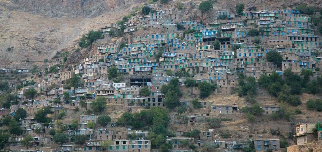
Uraman It is situated in a valley oriented from east to west, on a steep slope overlooking the northern part of the Takht Mountains, south of Marivan. Most of the houses in this village are stone and stair-shaped like Palangan and Masuleh. The beams cover the ceilings, the uneven stone blocks form the walls, and it could be said that the material used in the construction of the houses is that provided by the surrounding nature. The peculiar style of this village makes the roof of the lower house the courtyard of the upper house. The climate of this region in spring and summer is mild and pleasant, but very cold in winter. Uraman village is one of the attractive rural areas of Kurdistan which, in addition to its panoramic views, has an invaluable tourist capacity thanks to the annual organization of a wonderful ancient Peer Shahriar ceremony. The inhabitants of the region and their language are known as Hevarami because they speak a Kurdish language called Hevarami or Huramani which is one of the most famous Kurdish languages. The ancient fire temples in this area indicate that its inhabitants were Zoroastrians before converting to Islam. The Sirvan River flows from the deep valleys of this region and empties into Iraq. The border areas of Sirvan are called Ravar. In this region, the land is covered with walnut, pomegranate, fig and mulberry trees. Despite the adverse weather conditions, the inhabitants respect their traditions. Other holy places are the Oihang and Abdolahí mosques, the tomb of Loskeh Hijij, highly respected by the inhabitants of this region and other peoples of Kurdistan. Uraman engraving It is located on the Zinaneh mountain of Uraman and is carved in the shape of a half moon. Inside there is an engraving of a human figure
Uraman
It is situated in a valley oriented from east to west, on a steep slope overlooking the northern part of the Takht Mountains, south of Marivan. Most of the houses in this village are stone and stair-shaped like Palangan and Masuleh. The beams cover the ceilings, the uneven stone blocks form the walls, and it could be said that the material used in the construction of the houses is that provided by the surrounding nature. The peculiar style of this village makes the roof of the lower house the courtyard of the upper house.
The climate of this region in spring and summer is mild and pleasant, but very cold in winter. Uraman village is one of the attractive rural areas of Kurdistan which, in addition to its panoramic views, has an invaluable tourist capacity thanks to the annual organization of a wonderful ancient Peer Shahriar ceremony.
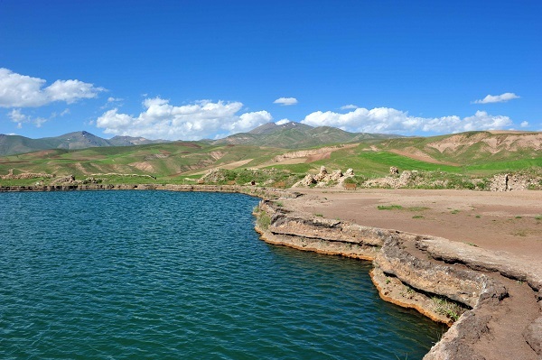
Takht-e Soleiman The archaeological site of Takht-e Soleiman, in northwestern Iran, is situated in a valley in the middle of a region of volcanic mountains. The site includes the main Zoroastrian shrine, partially rebuilt during the Ilkhani period (13th century), and a temple dedicated to Anahita from the Sassanid period (6th and 7th centuries). The architecture of the Temple of Fire, as well as that of the meeting rooms of kings and other palaces, significantly influenced architectural development during the Islamic period, which took place after the dissolution of the Sassanid rule in the 7th century AD. C. Takht-e Soleiman is also associated with beliefs much older than Zoroastrianism, as well as with important biblical figures and legends. The site consists of an oval platform that rises about 60m above the surrounding valley. It has a small limestone artesian well, which has formed a 120 m deep lake. From there, small streams carry water to the surrounding lands. The Sassanids occupied the site from the 5th century onwards, building the royal sanctuary there. The sanctuary was surrounded by a stone wall 13 meters high, 38 towers and two entrances to the north and south. The main building is the Zoroastrian Fire Temple or Azargoshnasb, which is located on the north shore of the lake. This brick-built temple has a square plan typical of Sassanid fire temples. This architectural criterion of the Sassanids became an exemplary model for the construction of other places of worship in the Islamic period. To the east of the temple, there is another square hall reserved for the "eternal fire." To the east is the Anahita temple and the royal residences are located to the west of the temples.
Takht-e Soleiman
The archaeological site of Takht-e Soleiman, in northwestern Iran, is situated in a valley in the middle of a region of volcanic mountains. The site includes the main Zoroastrian shrine, partially rebuilt during the Ilkhani period (13th century), and a temple dedicated to Anahita from the Sassanid period (6th and 7th centuries). The architecture of the Temple of Fire, as well as that of the meeting rooms of kings and other palaces, significantly influenced architectural development during the Islamic period, which took place after the dissolution of the Sassanid rule in the 7th century AD. C. Takht-e Soleiman is also associated with beliefs much older than Zoroastrianism, as well as with important biblical figures and legends.
The site consists of an oval platform that rises about 60m above the surrounding valley. It has a small limestone artesian well, which has formed a 120 m deep lake. From there, small streams carry water to the surrounding lands. The Sassanids occupied the site from the 5th century onwards, building the royal sanctuary there. The sanctuary was surrounded by a stone wall 13 meters high, 38 towers and two entrances to the north and south. The main building is the Zoroastrian Fire Temple or Azargoshnasb, which is located on the north shore of the lake. This brick-built temple has a square plan typical of Sassanid fire temples. This architectural criterion of the Sassanids became an exemplary model for the construction of other places of worship in the Islamic period. To the east of the temple, there is another square hall reserved for the “eternal fire.” To the east is the Anahita temple and the royal residences are located to the west of the temples.
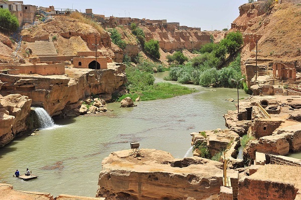
Shushtar One of the cities of the Khuzestan province, southwest of Iran on the banks of the Karun River. As it is surrounded by fertile plains, it has been an agricultural center since ancient times. The name Shushtar means better than Susa, the capital of the Elamites. After the Arab invasion of Susa, the Elamites established this new city, where it had a more pleasant climate and fertile lands. On the other hand, some historians believe that the root of the word Shushtar is six gates, since the city has six entrances, while another group believes that it originally means king's city. According to them, Shushtar was the first settlement of the first humans and, as some objects found in the Pebdeh cave show, the antiquity of the city dates back to ten thousand years ago. Shushtar's golden age occurred during the Sassanid dynasty (3rd-7th centuries), when they built an elaborate hydraulic system and canals to supply water to the area. Also, some inscriptions belonging to the Achaemenid era and some ceramic articles from the Arsacid dynasty have been discovered. Shushtar has many places of interest like; Zoroastrian tent, castles, Shushtar mosque, caravanserai, shrines and mansions. Shushtar's craft is diba, a type of handmade cloth. The ancient hydraulic system of this city was added to the UNESCO World Heritage list in 2009. The small and picturesque city, located at the confluence of two rivers, was saved from the destruction of the war between Iran and Iraq. Shushtar Hydraulic System The date of its construction dates back to the 3rd century, during the Sassanid reign to distribute the water of the Karun River. Considering its age, it is a masterpiece of civil engineering. The hydraulic system occupies a huge area, and the old water mills are the best known part. To
Shushtar
One of the cities of the Khuzestan province, southwest of Iranon the banks of the Karun River. As it is surrounded by fertile plains, it has been an agricultural center since ancient times. The name Shushtar means better than Susa, the capital of the Elamites. After the Arab invasion of Susa, the Elamites established this new city, where it had a more pleasant climate and fertile lands. On the other hand, some historians believe that the root of the word Shushtar is six gates, since the city has six entrances, while another group believes that it originally means king’s city. According to them, Shushtar was the first settlement of the first humans and, as some objects found in the Pebdeh cave show, the antiquity of the city dates back to ten thousand years ago.
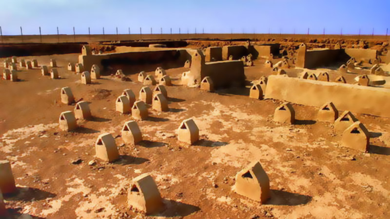
Shahr-e Sukhteh (Burnt City) This place is located 50 km from Zabul city. It is one of the largest urban settlements with more than 5,000 years old and occupies an area of about 150 hectares, located on a hill 12-18 meters high. Excavations in this area have uncovered many ancient objects, such as: ceramics, old metal, wood, stone objects that show the antiquity of the civilization of this area. Archaeologists divided the city into four parts: Central area with an area of 20 hectares whose objects date back to 2700 years before Christ. The East Zone, of 18 hectares and with an area of 16 hectares, corresponds to the second level of occupation of this city. The northwest area, where metal and stone objects have been found that indicate industrialization. The last zone includes a 25-hectare cemetery. The burned city has unique characteristics that distinguish it from other historical monuments in Iran. This city, despite its advance, lacked a temple or shrine, a wall, a fence, a moat, and even a defense system. The houses were made of clay and lime and were equipped. Archaeologists estimate that this city was inhabited for 1500 years.
Shahr-e Sukhteh (Burnt City)
This place is located 50 km from Zabul city. It is one of the largest urban settlements with more than 5,000 years old and occupies an area of about 150 hectares, located on a hill 12-18 meters high. Excavations in this area have uncovered many ancient objects, such as: ceramics, old metal, wood, stone objects that show the antiquity of the civilization of this area.
Archaeologists divided the city into four parts:
Central area with an area of 20 hectares whose objects date back to 2700 years before Christ.
The East Zone, of 18 hectares and with an area of 16 hectares, corresponds to the second level of occupation of this city.
The northwest area, where metal and stone objects have been found that indicate industrialization.
The last zone includes a 25-hectare cemetery.
The burned city has unique characteristics that distinguish it from other historical monuments in Iran. This city, despite its advance, lacked a temple or shrine, a wall, a fence, a moat, and even a defense system. The houses were made of clay and lime and were equipped. Archaeologists estimate that this city was inhabited for 1500 years.
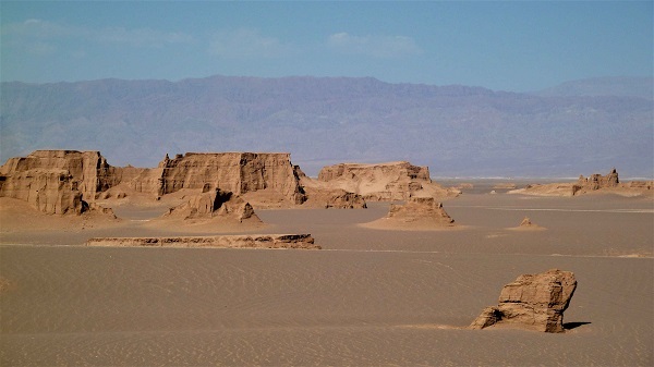
Shahdad One of the most historic cities in Iran, dating back to six thousand years ago. Of the wonders of Shahdad, it is enough to mention the first metal flags in the world, city of the dwarves and their kaluts where an alien landscape stretches before our eyes. The term kalut is composed of the terms Lut (the Lut Desert) and Kal (city). Kalut is also known under the name Yardang which means sand castle. In fact, the Kalutos are formations that have been created by the erosion of the wind, forming sand dunes in a thousand different ways. Located about 100 km northeast of Kerman, Shahdad is connected to the cold, mountainous Sirch region in the southwest and the desert regions in the northeast. The present Shahdad is like a triangle whose apex is inclined towards the Konaran Valley and its base is on the eastern side of the Takab region. It ends in the most important and exclusive parts of this desert area, namely the Kaluts, which run parallel to the edge of the Lut Desert. Khabis - the old name of Shahdad - with a height of 430 m above sea level is known as one of the important poles of the desert. Shahdad's water is supplied through the Derakhtangan River. Citrus, dates and garlic are grown in the gardens and on the village lands. The sharp rise in temperature in July has affected agriculture in disadvantaged areas of Shahdad. Being one of the largest parts of Iran and the oldest in the Kerman province, it contains some related vestiges from the 4th millennium BC. C., until contemporary Islamic periods, such as cemeteries, castles, inns, etc. There are salt marshes in the Shahdad desert, of which there are no similar examples anywhere else in the world. If
Shahdad
One of the most historic cities in Iran, dating back to six thousand years ago. Of the wonders of Shahdad, it is enough to mention the first metal flags in the world, city of the dwarves and their kaluts where an alien landscape stretches before our eyes. The term kalut is composed of the terms Lut (the Lut Desert) and Kal (city). Kalut is also known under the name Yardang which means sand castle. In fact, the Kalutos are formations that have been created by the erosion of the wind, forming sand dunes in a thousand different ways.
Saryazd Castle: Old Sasanian Bank Saryazd Castle is located near the Yazd-Kerman road and in the village of Saryazd, being one of the largest and most beautiful castles in Mehriz county. The castle dates from the Sassanid period, before the arrival of Islam in Iran. This monument is surrounded by a ditch six meters wide and four meters deep. The trench is considered the first layer of defense of the castle. The castle has two defensive walls and a fence. The outer fence, six meters high, is made up of three round towers and a square tower, and the inner fence, nine meters high, is made up of six round towers. The inner castle, dating from the Sassanid period, was built under a precise order on three floors, including the residential sector, the service sector, etc. The complexity of the interior spaces, together with the tower and walls, the simple and courteous geometric shapes and the beautiful exterior volume of the building are the unique characteristics that have made Saryazd Castle one of the most picturesque in the country. The magnificent fortress was used to store grain and food, but also to store valuables such as gold and jewelry when the city was attacked. This old bank is still in good shape and is well worth the trip from Yazd. The main exterior walls and towers are intact, surrounded by a moat, and the interior is filled with 450 rooms. The labyrinthine interior can be explored for hours. The construction of the Saryazd castle was such that it made access difficult. The small entrances and narrow corridors only allowed one person at a time. Pahlavanpur Garden Mahriz's Pahlavanpur Garden is related to the Qajar period and is located in the Mazvir Abad district. This garden is rare in the entire
Saryazd Castle: Old Sasanian Bank
Saryazd Castle is located near the Yazd-Kerman road and in the village of Saryazd, being one of the largest and most beautiful castles in Mehriz county. The castle dates from the Sassanid period, before the arrival of Islam in Iran. This monument is surrounded by a ditch six meters wide and four meters deep. The trench is considered the first layer of defense of the castle.
The castle has two defensive walls and a fence. The outer fence, six meters high, is made up of three round towers and a square tower, and the inner fence, nine meters high, is made up of six round towers. The inner castle, dating from the Sassanid period, was built under a precise order on three floors, including the residential sector, the service sector, etc.
Sareyn It is a city and capital of the county of Sareyn, 25 kilometers west of Ardebil, and has approximately 8,000 inhabitants, which exceeds 20,000 in summer due to its charming climate. The fame of this city is in debt to its hot springs and its springs are near a dormant volcano on Mount Sabalan. Most of the country's springs are located in western Azerbaijan, Mazandaran and Ardebil. The water from these springs contains sulfur particles, useful for bone and joint pain. In fact, Iranians have shown great interest in the therapeutic aspect of hot springs. Besides the kings, who built recreational centers on the edge of the springs, the Iranian people consider them of great importance religiously. According to popular belief, these springs are protected by divine forces, which is why they have supernatural power. Gavmish Goli, Ghotur Soui, Sari Sou, and Ghara Sou are among the most famous springs and attract many tourists annually. The pleasant climate and hot springs are the first attractions for tourists traveling to this region, and another tourist attraction is the Alvares ski resort, 24 kilometers from Sareyn with an altitude of 3,200 meters above sea level. Due to the large amount of snow, this station is usable between 6 and 8 months. In the historical town of Konzagh, in the suburbs of Sareyn, there are caves related to the Parthian period, registered in the list of the national heritages of Iran.
Sareyn
It is a city and capital of the county of Sareyn, 25 kilometers west of Ardebil, and has approximately 8,000 inhabitants, which exceeds 20,000 in summer due to its charming climate. The fame of this city is in debt to its hot springs and its springs are near a dormant volcano on Mount Sabalan. Most of the country’s springs are located in western Azerbaijan, Mazandaran and Ardebil. The water from these springs contains sulfur particles, useful for bone and joint pain. In fact, Iranians have shown great interest in the therapeutic aspect of hot springs.